

A landmark resolution was adopted by the United Nations General Assembly, resolution “Correct the Map: rebalancing global cartographic representation and promoting a more equitable representation of the world’s regions” with 164 votes in favor, against only 1 by the United States, while 6 Member States chose to abstain.
The resolution tabled by Togo has secured the support of the African Union and seeks to encourage governments, educational institutions, international organisations, media and technology companies to adopt equal-area map projections.
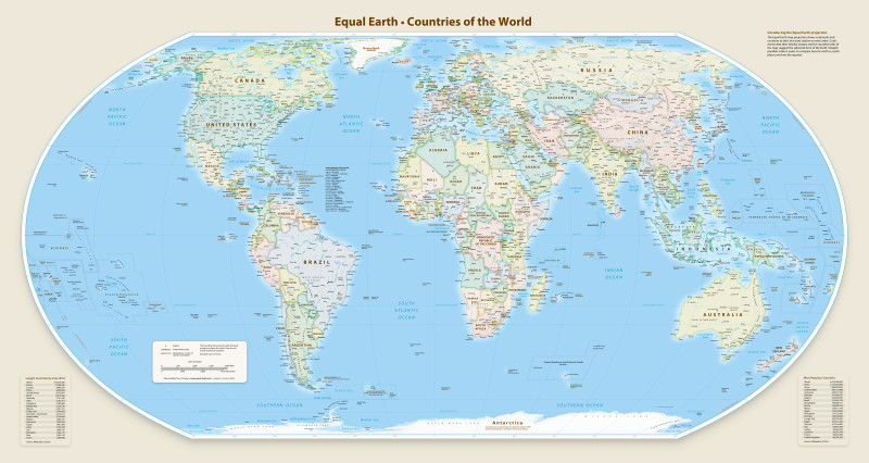
The Equal Earth cartographic projection is aimed at helping improve “the accuracy of the cartographic representation of the world,” seeking to encourage the Equal Earth projection and other so-called equal-area maps when relative size matters, and to teach the limitations of any flat map in representing a spherical planet.
“Africa is at the centre of this century, yet the world still pictures it through a tool designed for sixteenth-century navigation, at half its true size. That gap between reality and representation has a cost in how Africa is taught, reported, negotiated with and invested in. This resolution shifts the burden of proof onto those who would keep the distortion. Our job now is to make sure the classroom, the newsroom and the screen catch up with the vote, commented the Deputy Executive Director, Speak Up Africa Fara Ndiaye.
“Maps shape our understanding of the world,” Togo’s foreign minister, Robert Dussey emphasised before casting of the vote. “They guide education, nourish the imagination, and influence collective perceptions.”
Designed in 1569 for European maritime navigation, Mercator preserves angles at the expense of area, showing Africa at roughly half its true scale while enlarging Europe and North America. On a Mercator map, Africa and Greenland appear similar in size; in reality, Africa is about fourteen times larger.
The UN has observed that Greenland can look roughly comparable in size to Africa, even though Africa is about 14 times larger. Northern Europe and North America are similarly magnified, relative to equatorial regions.
Despite its original navigational purpose, Mercator remains common in educational, media, digital, and official materials. The resolution says that such distortions have contributed to the “symbolic minimization” of Africa and perpetuated an unbalanced view
Speak Up Africa and Africa No Filter launched the Correct the Map campaign to challenge this distortion and call for maps that reflect Africa’s true dimensions in classrooms, media and public life. There were more than 11,000 citizens joining the movement by signing the Correct the Map petition, alongside educators, researchers and partners across the continent and beyond.
The campaign also received the formal support of the African Union in June 2025, through the leadership and championing of Deputy Chairperson, H.E. Ambassador Selma Malika Haddadi, which transformed a civic demand into a continental political position, before Togo carried it to the General Assembly.
There was a need for a fair map where the resolution describes correcting such distortions as an act of “cognitive justice and memorial reparation” and points to Equal Earth, developed in 2018, as a projection that more accurately represents relative size.
Africa constitutes the second-largest continent by land area and population, and by 2050 one in four people on earth will be African. The continent is central to the defining questions of this century: climate, energy, trade, demography, security and innovation. Correct the Map argues that the way the world pictures Africa should match that reality.
The distortion is not confined to Africa. The Mercator projection reduces the apparent size of the entire equatorial belt, including South America, South Asia and Southeast Asia. Equal-area projections such as Equal Earth, which preserve the true proportions of continents while retaining familiar shapes, are freely available and widely used in scientific and educational settings.
What comes next
Following the vote, Speak Up Africa and Africa No Filter will focus on implementation across five areas:
- The United Nations system: applying the resolution to its own reports, publications and public materials, so that member states and international organisations have a model to follow.
- Education: working with ministries of education, beginning with African Union member states, to integrate equal-area maps into curricula, textbooks and classroom materials.
- Media and publishing: engaging newsrooms, publishers and editorial bodies to adopt accurate projections wherever the relative size of regions is relevant.
- Digital platforms: calling on technology companies to change default map settings where the true scale of continents matters, recognising that most people now encounter the world through a screen.
- Tracking progress and accountability: monitor the adoption of equal-area projections across governments, institutions, media and digital platforms, highlight early adopters and document progress over time.